

A magazine where the digital world meets the real world.
On the web
- Home
- Browse by date
- Browse by topic
- Enter the maze
- Follow our blog
- Follow us on Twitter
- Resources for teachers
- Subscribe
In print
What is cs4fn?
- About us
- Contact us
- Partners
- Privacy and cookies
- Copyright and contributions
- Links to other fun sites
- Complete our questionnaire, give us feedback
Search:
The eye of the storm
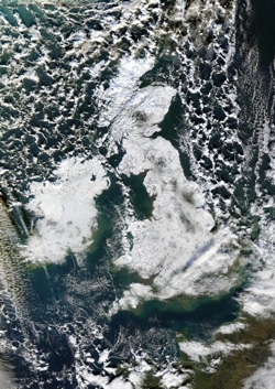
Next time a really big storm passes over that feels awesome from below, why not look at it from above as well? You can the next day.
It will be there in the Dundee Satellite Receiving Station Archive. Whenever a satellite passes over, the Dundee computers automatically suck up the data it’s transmitting. That data isn’t just numbers – the numbers turn into stunning pictures of the earth taken by the satellite as it passed by. Some of the satellites – geostationary ones – sit over the same point on earth all the time and take an image of that place every 15 minutes. That means if there is a geostationary satellite above you then you can even track the eye of a storm when it passes over.
Perhaps you’ve heard about forest fires raging across the continent. Are they visible from space? Go and have a look. What about volcanoes erupting, oil refineries exploding or algae blooming? They’re all there, with lots more too. The images look amazing but they have a serious side too. Environmental scientists use them in their research, tracking changes to the planet: from changes in land use to investigating algal blooms. Satellite images are a godsend to researchers.
Computer scientists may not always be saving the planet directly, but from creating the code that allows satellites to send data, to helping turn numbers into the stunning images that make people take notice of problems, computer scientists are helping.